A symbol of Sidney’s fight to become a municipality in the early 1900s has been rediscovered and soon it will be available for all to see.
But it’s not as though this piece of Sidney’s history was lost altogether.
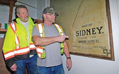
Brad Morrison of the Sidney Archives heard about a map dating from 1913, hanging in the Town’s public works building. He found it there, a tall frame with glass encasing the map — hanging on a wall behind a working wood lathe in the carpenters’ shop.
Morrison said he immediately knew it was the real thing and it needed to get a bigger audience.
So, he has arranged with the Town to have the map removed from the works yard and have it put on display at the Sidney Museum on Beacon Avenue.
“It’s the map that the Town produced for the first time it asked to be incorporated as a municipality,” Morrison said.
In an excerpt from the Town of Sidney’s Town Talk newsletter, Morrison penned a brief outline of what happened in 1913 when the Sidney Board of Trade petitioned the province to become a village.
The Premier, citing the trouble of other smaller B.C. communities to take on the financial responsibilities of being a municipality, rejected Sidney’s bid. It was, after all, only the year before that the Board of Trade — and the Sidney and Islands Review newspaper — was formed. It took nearly another 40 years until Sidney was declared a village in 1952. It was incorporated as the Town of Sidney in 1967.
The 1913 map shows the Board of Trade was hopeful that year — it says it’s a “map of Sidney, incorporated in 1913.”
Dan Loveridge and Jim Iverson, carpenters for the Town, found the map in their building six or seven years ago. No one seems quite sure when it was placed there, most estimating that it probably arrived there 20 years ago. Prior to that, it was stored in the basement of town hall. Morrison noted it may have been on display at some point after it was created.
Loveridge and Iverson said they enjoyed having it up on the wall.
It shows early residential areas, three rail lines and a rail terminal wharf on the waterfront. It’s also missing a few things that would come later — the Pat Bay Aerodrome (now Victoria International Airport) in 1938/’39 and the Pat Bay Highway that essentially cut the community in half.
The fact the map has printed on it: “Sidney, incorporated in 1913” makes the map a bit of a novelty, Morrison said — at the very least a one-of-a-kind.